
Archive Record
Images
Metadata
Catalog Number |
1902.1.9 |
Title |
Waterbury Airport |
Collection |
Maps & Posters |
Object Name |
Map |
Scope & Content |
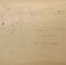
This is a survey map of Waterbury Airport by the Vermont Aeronautics Commission 02/11/1958. It shows a profile of the approach area CAA TSO N18 and cross section for cutting pines on the north approach. There are two copies of the map. |
Date |
02/11/1958 |
Search Terms |
Waterbury-Stowe Road Waterbury, VT Waterbury Center, VT Waterbury Airport Route 100 |
Subjects |
Maps Survey drawings Airports |
Imagefile |
016\190219.JPG |