
Archive Record
Images
Metadata
Catalog Number |
1902.1.30 |
Title |
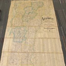
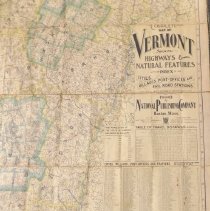
Complete Map of Vermont |
Collection |
Maps & Posters |
Object Name |
Map |
Scope & Content |
This is the Complete Map of Vermont showing highways and natural features with an index of all cities, villages, post offices and railroad stations. It includes population information and travel distances. It was published by the National Publishing Company, Boston, Mass. Its scale is 3 miles to an inch. It is color printed on oil cloth. The last Vermont population census listed is for 1900 (population 343,641), thus the map is assumed to be from early 1900s. |
Date |
Early 1900s |
Search Terms |
State of Vermont |
Subjects |
Maps Counties Highways Roads Cities & towns Villages Post offices Railroad stations |
Imagefile |
019\1902130.JPG |